Sent to Mareeba Shire Council 29 July 2016
Dear Councillor
We are concerned that council’s investigation of the preferred area No. 3 Clohesy River area (which covers the whole of Koah past the Koah service station down to the Barron river) might lead to a reduction of the minimum lot size of the rural zone in that area.
We think a reduction of lot size is not appropriate and may lead to damage of our wildlife (see https://www.facebook.com/koahwildlife/ celebrating just some of the wildlife found in Koah).
For the following reasons, we ask council to revisit the decision to investigate this area. This will save wasting ratepayers’ money.
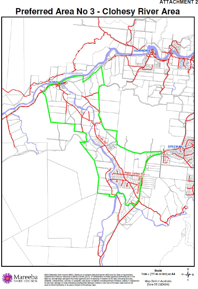
Picture right:
Green outline shows preferred area No 3,
which covers the whole of Koah
past the Koah service station down to the Barron river.
Bushfire hazard
A large percentage of the mapped out area lies either within bushfire hazard area medium or high. An increase of population in those areas would strain an already stretched rural fire brigade and put residents at risk.
Picture right:
MSC plan 2016
overlay map
Bushfire Hazard
Speewah
Green outline shows preferred area No 3

Review of the Environmental Significance Overlay
It appears inappropriate to address the Koah matter before the ‘Review of the Environmental Significance Overlay to include matters of local environmental significance which did not transition from the 2013 version of the draft planning scheme in accordance with Council’s resolution of 3 Feb 2016 Ordinary Meeting.’
There would seem to be some overlap between the two proposals. It would be logical and avoid doubling up if the council investigation of the Koah area takes place after the input of the paid consultant on the matters of local environmental significance. Indeed essential wildlife corridors linking different protected areas are missing in the new 2016 plan and the current general level of environmental protection is very poor in Koah.
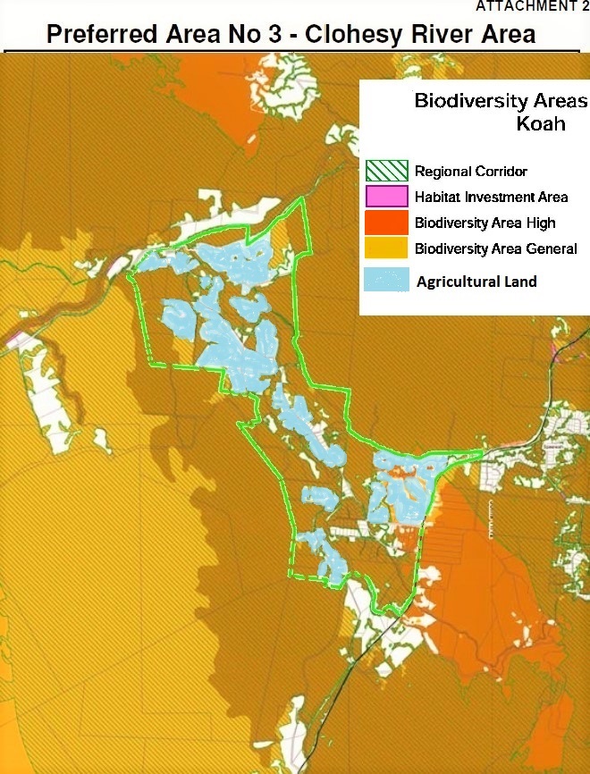
Biodiversity & Remnant Vegetation
A large percentage of the area in question is covered with remnant vegetation which was either classed as Biodiversity area high, general and/or a regional corridor in the previous draft plan 2013. Council has committed to review including these values in the current plan.
Picture right:
TRC 2013 draft plan
Biodiversity Areas Overlay Map
Koah
Green outline shows preferred area No 3
Federally listed Environment Protection & Biodiversity Conservation listed endangered species
The remnant vegetation includes federally listed EPBC listed endangered species for example the in Koah widely distributed Broad Leaf Tea-tree. Any more subdividing would invariably trigger EPBC compliance as the current bushfire hazard code requires the clearing of 20m wide perimeter fire breaks. The endangered Northern Quoll would also be impacted on negatively as well as the in Queensland as endangered listed Northern Bettong, both found in the area in question.
Agricultural Land like fruit orchards, cattle grazing, vegetable production
Though not mapped as good agricultural land, most of the cleared land has been and still is under agricultural production. The Koah Clean Harvest Foodbowl movement is gathering momentum which encourages local Koah farmers to produce clean, locally grown food. It would be wise to preserve this valuable farmland so we can continue growing food locally, especially since the future may well present us with unforeseen circumstances.
Picture right:
TRC 2013 draft plan
Biodiversity Overlay Map with land currently under agricultural production colored blue
Green outline shows preferred area No 3
Contaminated Water
Domestic water is an issue in Koah. Bore water can not be relied on as some bores are so heavily contaminated with Arsenic that they are not safe to use. A heavy metal water test of the Clohesy River last December showed contamination of Arsenic, Lead and Cadmium. The same lab Council uses (ALS laboratories) conducted the test.
Flooding & Some of Koah cut off in the Wet
The other side of the new Clohesy River bridge can still get cut off in the wet season. So can the other side of the Groves Creek crossing along Fantin Road, leaving residents sometimes marooned either side.
We look forward to hearing from you.
Regards
Nadine O’Brien
Kuranda Region Planning Group
Received from Mareeba Shire Council 2 August 2016
Hi Nadine,
Thank you for your correspondence circulated to Councillors in relation to rural land use planning in the Koah locality.
As you are aware, Council at its ordinary meeting held on 15 June 2016 passed the following resolution:
Council request that Council officers progress an investigation into a potential rural precinct area centred around Koah Road and to encompass all land within Preferred Area No 3 – Clohesy River Area of the Mareeba Shire Planning Scheme 2004, and report back to Council with a recommendation on the preferred minimum lot size for the rural zone in this area.
Council notes the views expressed in your email and will keep them in mind when the requested report is presented for Council’s further consideration.
Regards,
Peter Franks
Chief Executive Officer
sent Sun, Aug 14, 2016
Dear Mayor and cced CEO, Councillors and Brian Millard
We ask that the following motion is read out at the next council meeting and formally voted on: ‘ We resolve to postpone the investigation into the ‘preferred Area No.3 – Clohesy River Area’ until the review of Environmental Significance Overlay to include matters of local environmental significance which did not transition from the 2013 version of the draft planning scheme is completed.’ This would be desirable as in the current plan there is little protection of wildlife corridors and remnant vegetation in Koah. Please see below two maps for your convenience: 1. Map of Preferred Area No. 3 – Clohesy River Area( i.e. Koah north of the Kennedy Highway down to the Barron river) 2. Map of the Biodiversity Overlay from the 2013 plan showing matters of local environmental significance that have not yet been carried over into the new plan. We understand from Cllr Wyatt that it is highly likely that these will occur in this order anyway. However we would welcome council’s assurance that this will be so by this motion being passed.

Green outline shows preferred area No 3, which covers the whole of Koah past the Koah service station down to the Barron river

TRC 2013 draft plan Biodiversity Areas Overlay Map Koah. Green outline shows preferred area No 3
Sent to MSC on Tue, Aug 16, 2016
Dear Council
Further regarding the investigation of the preferred area No.3 – Clohesy River area.
We would like to draw special attention again to the under the EPBC listed endangered Melaleuca viridiflora(Broad leaf tea-tree) which is broadly distributed in the area in question.
A link to the EPBC listing advice is here: http://www.environment.gov.au/biodiversity/threatened/communities/pubs/122listing-advice.pdf
Council is required to take into account the EPBC listed ecological community on the land which is the subject of the planning scheme amendment.
Planning schemes and their amendment are governed by the Sustainable Planning Act 2009 (SPA).
Section 88 of SPA provides that a planning scheme can deal with three key elements: land use and development; infrastructure and value features.
Valuable features include areas of ecological significance (s89 SPA). Under s 117 SPA the process for amending a planning scheme is set out in a Ministerial Guideline. The current Ministerial Guideline is Statutory guideline 04/14 – Making and amending local planning instruments dated 9.10.2014 and prepared by the planning department.
Here is a link to it: http://www.dilgp.qld.gov.au/resources/planning/planning/statutory-guideline-04-14.pdf
In the Guideline, clause 4.1(d)(v) (on page 12) provides that when amending a planning scheme a Council must provide a statement to the Planning Minister about how the key elements (see above at s 88) have been addressed and at 4.1(d)(v) provide any background studies. So in this case Council would need to provide a statement about how any impacts on the Broad leaf tea-tree community will be addressed and provide any studies about it.
Also when the investigation commences this matter should be referred to the Commonwealth Department of Environment and Energy under the Environment Protection and Biodiversity Conservation Act 1999 as it would be a controlled action.
Please see images of Broad leaf tea-tree below
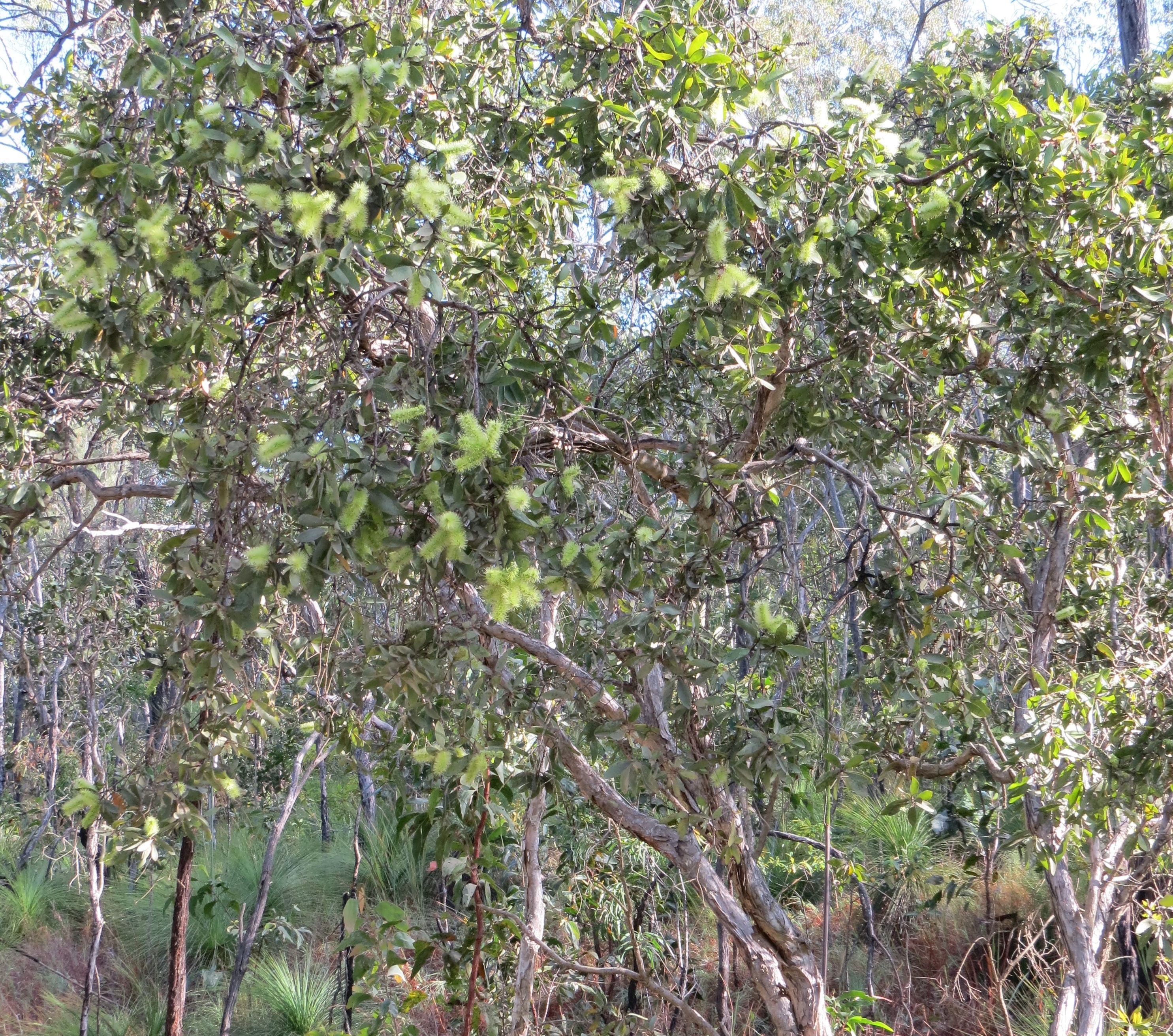
Melaleuca viridiflora(Broad leaf tea-tree)

Melaleuca viridiflora(Broad leaf tea-tree)